It is a snowshoeing adventure to turn an ordinary walk into an enchanted journey through snowy forests and valleys.
There are numerous routes to explore while wearing snowshoes and unique opportunities to fully immerse yourself in the peace and tranquility of winter in the mountains. Every week, the Alpine Guides are ready to accompany you and offer various excursions along the white paths of Alta Valtellina. If, on the other hand, you feel ready to tackle the itineraries without the guidance of experts, there are also several snowshoeing routes that you can undertake on your own.

Pezzel
Scenic trail with modular development along several loops. It is not mainly sunny so that it can be hiked with snowshoes until late spring. Large car park at the start.
- Length: 5 Km 532 m
- Time: 1 h 50 min
- Height difference: 333 m
Pezzel del Maestro
Almost completely flat track that runs along both banks of the Viola stream. Particularly suitable for children. At the Isolaccia sports field, there is a bar and ample parking.
- Length: 3,7 km
- Time: 1 h 25 min
- Height difference: 78 m


Giro Felice
The route is named after Felice Rocca, who first intuited the possibility of marking and climbing this route.
It starts from the locality of Zardin in Isolaccia and, in the first part, climbs the road that in summer leads through the locality of Pezzel to the Madonnina di Prescendont and, from there, after entering the Val di Borron to the locality of Ciuk. This is where the route starts, with minimal and regular gradients, leading through the Pone pastures and the beautiful Swiss stone pine forests. Once you reach the furrow of the Val Bocciana, you cross Ponte Felice, and after a few uphill switchbacks, you will arrive near the arrival station of the Palancana ski lift.
- Length: 8 Km 295 m
- Time: 3 h 40 min
- Height difference: 858 m
Val Fochin
Path immersed in the forest that is part of the beaten winter itineraries of Valdidentro; from the locality Tres, you can reach the Ristoro Conca Bianca, located at the arrival of the Isolaccia cableway
From the locality of Tres, where there is a parking lot with a limited number of parking spaces, go up towards Via dell'Artigianato, passing by the side of the bicycle path and the sheds present, and then take the path N282 just above that, entering the woods, leads towards the Baite di Fochin. With a total elevation gain of about 700 meters, the trail winds through the forest, with some panoramic views on the opposite side. The final section laps a concise section of the ski slope, so caution is required. The trail ends at the gondola's arrival near the Conca Bianca Inn. From here, it is possible to return to the valley from the same route or use the aid of the gondola.
N.B. Since the snowcat has beaten this path, it is advisable to check the updated situation by contacting the Valdidentro Tourist Office before taking the route.
- Length: 9,6 Km (A+R)
- Time: 4 h 25 m
- Height difference: 673 m


Strada del Bosco
It is a demanding route in terms of altitude difference and the gradient of some of its sections. The path climbs from S. Carlo to join the Decauville. The difficulty of the route is entirely repaid by the value of a road that runs entirely through the forest. Return round trip by descending from the Decauville along the old mule track via La Tea, Pian del Beppo, and Teola. Possibility of parking at the start, in San Carlo.
- Length: 5 Km 612 m
- Time: 1 h 50 min
- Height difference: 346 m
Val Viola - Lower road
Easy trail to snowshoe that connects Arnoga to the Caricc area via the low flat trail.
In Arnoga, from the parking lot near Baita Viola, you take the low trail N201.1, the natural continuation of the Decauville that, until just before the junction with the road to Verva, is primarily flat and inside the forest. Once you reach the end of the flat, you connect to the N293 trail present just above that leads in the direction of Caricc. This path in the forest is not too steeply ascending and leads towards the water intake. Once you pass the passage near the outlet, you will join the road that leads to Caricc Agritourism. Once at the agritourism, retrace the path to winter to return to Arnoga.
- Length: 11,1 Km (A+R)
- Time: 3h 50 min
- Height difference: 136 m


Val Viola - Baite Cagnol
The trail's starting point is the high car park in Arnoga, Valdidentro. The route, immersed in nature, leads directly to the Baite Cagnol huts, from where one proceeds into the woods, following the path and ascending toward Sattarona. Once out of the woods, you can enjoy a breathtaking view of the surrounding mountains, including Cima Piazzi with its glacier and Corno Dosdè, as well as the valley below.
Bring the obligatory self-rescue equipment: shovel, ARTVA, and probe.
Wear suitable clothing: windbreaker, gloves, cap, sunglasses, mountain boots or heavy winter shoes (no wide-bottomed padded ones), rucksack, gaiters, ski poles, and snowshoes.
- Length: 6 Km 505 m
- Time: 3 h 40 min
- Height difference: 347 m
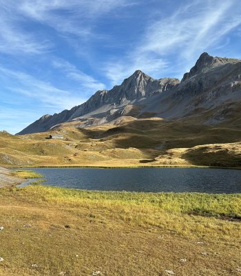
Val Viola
A very gentle track, which in the central part offers two alternative routes, leads through woods of spruce, larch and stone pine to the Caricc malga clearing, in an enchanting position below the peaks of the Dosdé _ Viola group and their glaciers. The malga, from which it is possible to reach a picturesque gorge, is usually open in winter.
Thanks to the special signposts, the route can also be undertaken at night, provided a headlamp is used.
- Length: 10,9 km
- Time: 3 h 57 min
- Height difference: 281 m

 Info & commuications
 Info & commuications
 Info & commuications
 Info & commuications
 Info & commuications