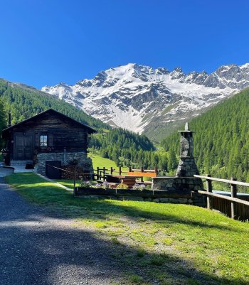
Explore the world of ski mountaineering on these medium-difficulty routes and move with awareness between the immaculate snow-covered valleys.
Ski mountaineering is an extraordinary but inherently risky activity. It is essential to have the appropriate equipment, to know the terrain and the chosen route, and to have up-to-date information on weather and snow conditions. Carefully assess the difficulty of the route and the equipment required. Always carry crampons, an ice axe, and the ARVA emergency kit, shovel, and probe in your rucksack.
If you need advice, please feel free to contact the Alpine Guides. They will guide you in your first technical steps and safely tackle the mountains. You can also ask for their advice about renting or buying equipment from specialized shops.

Punta di Avedo
Beautiful skiing on the Dosdè glacier with this exciting ski tour, with constant gradients leading to Punta d'Avedo. A stunning panorama of the entire Val Viola and Val Grosina. It is a pleasant itinerary within everyone's reach.
From Arnoga, follow the road that enters Val Viola, passing the Dosso, Permogli, and Alpe Campo huts. Just before the Altumeira summer hut, descend to the Baita Caricc; just before or after the hut, cross over a small bridge on the opposite side and climb up to the Dosdè plain. Passing near the Federico refuge in Dosdè, continue on the plain, keeping to the left of the Viola torrent, and just before an evident cliff, follow a small valley that leads to a plateau. Continue more or less keeping to the center of the impluvium, arriving at the Vedretta di Dosdè. Climb the right-hand side and gradually reach the glacier's center in a flat area. Continue aiming to the right of the final rocky cusp of the summit. With slopes that become steeper and steeper, passing to the left of a rocky spur, you reach the final slope that leads to the right side of the summit and climb it in the less steep area, from the western col in short order to the summit.
- Length: 11 Km 574 m
- Time: 6 h 20 min
- Height difference: 1314 m
Rasin - Cuna Alta
Starting at the Rasin Multifunctional Center (with a huge parking lot), the route heads past the cross-country ski track and into the Fogarola forest. It then follows the Fochin path and leads to the ski area. The last stretch climbs through the woods towards Mount Massuco, reaching the Conca Bianca refuge and connecting with the slopes. At this point, you can go back to Rasin through the slopes.
This trail is part of the Stelvio Skimo Natural Trail project, which aims to introduce beginners to ski mountaineering. The trails are regularly maintained and monitored, providing a safe environment that connects to the slopes for a safe descent.
- Length: 5 km 700 m
- Time: 2:30h
- Height difference: 725


Monte Cornaccia
It is an enriching ski mountaineering tour from an environmental and scenic point of view, which runs along the Cancano valley and on steep slopes up to the northeast ridge on the Swiss border. The final section is a little exposed and steep, but worth reaching the summit with care.
From the Ristoro Solena near the little church of Cancano, follow the minor road to the left, which runs alongside the Cancano reservoir for about one kilometer until you reach where a prominent, steep little valley rises to the right. Depending on the snow conditions, climb up the right-hand bank or walk along the bottom. When the terrain softens, continue for another hundred meters and climb up the slope to the right and gradually to the left, taking in the plateaus above, always heading north.
When you reach a hollow, continue along the slope to the left and then north again for about 200 meters. Then, climb the steep, wide gully that leads to a ridge pass.
From here to the left, following the northeast ridge, you quickly reach the summit and descend westwards for a few dozen meters to reach the base of the final part of the climb. Follow the ridge and then to the leftover steep, exposed terrain to reach the summit.
- Length: 4 Km 867 m
- Time: 5 h 35 min
- Height difference: 1.198 m
Pizzo Dosdè
This is a beautiful and complete ski mountaineering itinerary that touches on one of the most remote corners of the Val Viola. The more or less constant gradients and the various exposures over which the route winds make it a pleasant route for everyone.
From Arnoga, follow the road that enters Val Viola, passing the Dosso, Permoglia, and Alpe Campo huts, and just before the Altumeira summer hut, descend to the Baita Caricc; either just before or just after the hut, cross a small bridge on the opposite side and climb to the Dosdè plain. Passing close to the Federico refuge in Dosdè, continue on the plain, keeping to the left of the Viola torrent, and just before a prominent crag, follow a small valley that leads to a plateau. Continue more or less keeping to the center of the impluvium, arriving at the Vedretta di Dosdè. Climb up the right-hand side and gradually, where a falsopiano begins, head left, following a small valley that leads to a steep slope to be overcome to the left; passing now under the basal slopes of the Sassi Rossi, continue in a semicircle to the southern slopes of Pizzo Dosdè; staying more or less in the center of the hill, climb up and soon reach the summit.
- Length: 12 Km 642 m
- Time: 7 h
- Height difference: 1.478 m


Monte Corno
It is an enriching ski mountaineering tour from an environmental and scenic point of view. It runs along the Cancano valley and on steep slopes up to the northeast ridge on the Swiss border. The final section is a little exposed and steep, but it is worth reaching the summit with care.
Start just before the Foscagno Pass in Angelina's hamlet, in front of the Interalpen hotel, and follow the broad plain that leads towards the right to an evident gully. Climb the gully almost up to the ridge to the left, following it to the summit.
- Length: 2 Km 402 m
- Time: 2 h 40 min
- Height difference: 738 m
Monte di Foscagno
This beautiful itinerary is carried out mainly in springtime or with stable snow. It offers a varied morphology and follows steep slopes, small valleys, ridges, and gullies.
From the second hairpin bend below the Foscagno customs house, towards Livigno, enter the small valley floor gradually heading to the right and, having passed a series of bumps, reach a steep slope that is overcome from the left ascending to the right. When you get a ridge, follow along some gullies, fallopian, and steep slopes, arriving at the vast final amphitheater. Cross it from left to right, arriving on a flat area, to the right in a short time to the summit.
- Length: 2 Km 148 m
- Time: 2 h 15 min
- Height difference: 639 m


Monte Rinalpi
The ski mountaineering trip to Monte Rinalpi, or instead to the Vallone di Rinalpi, is undoubtedly one of those trips that deserve a bit of effort, the long difference in altitude and the development to make a good ski tour in a unique, solitary, and rewarding place. Entering the wide valley after the Boron Malga, one is greeted by a very harmonious morphology of the snowy terrain, and our tracks going up these slopes should also be so. The Vallone di Rinalpi, due to its favorable exposure, is one of the places that suffer little from the effect of the wind, so the descent will almost always be on powdery, fabulous snow that you will remember for a while. The view of the summit is spectacular.
From the parking area in Isolaccia, climb following the little road that, passing by the Baite di Pezzel, leads to the little church of Prescedont at 1750 m altitude. Following the signs for the Malga Boron hut, we again enter the beautiful larch and fir forest and shortly afterward begin to catch sight of the imposing northern slope of Cima Piazzi. Having passed the Boron huts, continue along the hillside to a vast plateau. Now turn left and enter a valley that rises between a morainic edge and the western slopes of the Corno di San Colombano. Having passed a steep section in the center, a logical and evident route takes us close to Colle di Rinalpi. We now climb northwards up the last steep section and then turn south again, climbing the last few meters that lead to the summit.
- Length: 10 Km 508 m
- Time: 6 h 40 min
- Height difference: 1.659 m
Monte Trela
This is a beautiful ski mountaineering route, simple and very panoramic over the entire Valtellina. It follows the entire southeastern mountain ridge, which can already be seen from the Valdidentro valley floor.
From Sant'Antonio di Scianno, follow the pretty little road that climbs slightly uphill through the forest. After a few bends, you arrive at the first huts of Alpe Gattonino. From here, staying on the right-hand edge of the meadow area, climb northwards to the Plator houses. Now, follow the wide ridge to reach the summit.
- Length: 2 Km 971 m
- Time: 3 h 50 min
- Height difference: 980 m


Bocchette di Verva
This route has considerable development and moderate gradients in an area hardly frequented in winter. The Val Verva is monotonous, but the final gully makes this out-of-the-way route attractive.
From Arnoga near the low parking area, enter Val Viola following the old mule track that enters flat until it passes Baite di Campo. Continue until you meet the deviation for Val Verva, descending to the Viola River.
After crossing the bridge, after a short up-and-downhill stretch, the trail begins to climb again, arriving near the Baite di Verva huts. Continue on the right side of the valley, following the little road until you reach the Alpe di Verva and continue on the same side.
Five hundred meters before the Verva pass, we gradually deviate to the left, arriving at the base of the western slopes of the Cima Piazzi. Keeping a reasonable distance to the southeast, we reach the Verva lake, passing it preferably on the left. From here, the gorge is visible, and in a southerly direction, one ascends it without any particular problems until reaching the pass.
- Length: 11 Km 237 m
- Time: 5 h 40 min
- Height difference: 1.091 m
Monte Forcellina - Val Viola
One of the most beautiful winter ski tours in Alta Valtellina. It has a varied and complete itinerary in every respect: scenic, environmental, and panoramic. It is also worthwhile for the technical aspect of the choice of itinerary and for the guaranteed fun downhill in fresh snow or spring firn on the wide slopes previously climbed.
From Arnoga, follow the carriage road that runs halfway up the Val Viola; past the Permoglia huts, you arrive where the road gradually begins to climb. Almost at the end of the climb, you take the diversions to the right for the Sattarona huts, and with a few long hairpin bends, gradually to the left, you reach the wooded edge. From the last huts, climb in a northerly direction, following a series of short slopes alternating with valleys, and you reach the center of the broad valley. Continue toward a rocky spur, pass it on the right, and arrive on a ledge. From here, you again cross a steep section on an open slope and then, in succession, another at the beginning of a narrow valley. Enter in a north-westerly direction, and after a few hundred meters, turn left, arriving on a ridge; follow it first westwards and then northwards, arriving at the summit.
- Length: 5 Km 448 m
- Time: 4 h 45 min
- Height difference: 1.195 m

 Info & commuications