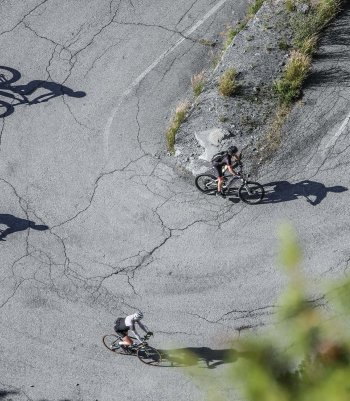
Experience ski mountaineering on these accessible trails and navigate safely through the pristine snowy valleys.
Ski mountaineering is an extraordinary but inherently risky activity. It is essential to have the appropriate equipment, to know the terrain and the chosen route, and to have up-to-date information on weather and snow conditions. Carefully assess the difficulty of the route and the equipment required. Always carry crampons, an ice axe, and the ARVA emergency kit, shovel, and probe in your rucksack.
If you need advice, please feel free to contact the Alpine Guides. They will guide you in your first technical steps and safely tackle the mountains. You can also ask for their advice about renting or buying equipment from specialized shops.

Corno la Resa
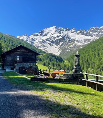
Solitary and peaceful places are the characteristics of this exciting and not-too-long ski mountaineering itinerary, with unique environmental and landscape aspects. From the summit, a vast panorama over the entire Viola valley.
From Arnoga, follow the carriage road halfway up the Val Viola. Past the Permoglia huts, you arrive, where the road gradually begins to climb.
Almost at the end of the climb, you take the diversions to the right for the Sattarona huts, and with a few long hairpin bends, gradually to the left, you reach the wooded boundary.
From here, heading decisively to the left, you enter a vast amphitheater, and, having passed a series of humps, small valleys, and short shelves, you reach the base of the final slope. Follow a counter slope to the left and the final steep section to reach the final ridge. Bending to the right, one can walk along the ridge for a stretch to a high point.
- Length: 5 Km 77 m
- Time: 3 h 46 min
- Height difference: 949 m
Croce della Cima del Bosco
This is a simple but very interesting route, both in terms of the environment and the views. The quality of the snow is usually very good, and it offers some nice descents.
From Arnoga, near the low parking area, enter Val Viola, following the old mule track that becomes flat until it passes the Baite di Campo.
Continue until you come to the deviation for the Verva Valley, descending to the Viola River. After passing the bridge, after a short up and downhill stretch, the trail begins to climb again, arriving in the vicinity of the Baite di Verva Bassa huts. Leaving the Verva valley, climb to the right to the baite di Verva Alta and continue into the forest, following the broad ridge that gradually loses its slope in the upper part.
Once out of the wooded area, continue past a series of humps and small valleys, reaching the end of the ridge.
- Length: 6 Km 385 m
- Time: 3 h 43 min
- Height difference: 744 m


Motta Grande
This is a mountain for all seasons, and when snow gently blankets its slopes, it is one of the first ski mountaineering ascents to be traced. Wide slopes are available on the southern side, and the ascent routes are never obligatory except for short sections on the final steepest slopes. The easy access and low altitude differences mean that ski mountaineering trips of even a few hours can be comfortably undertaken; the sunny environment also makes the climbs pleasant even in cold weather.
From the 'Baite di Preguzzon' car park on the left, three hundred meters ahead of the Arnoga hairpin bend, go up following a clearing to the left that leads you through a stretch of woodland to the Baite Cagnol (2015 m) near an old ski lift that has been out of use for years (this point can also be reached from the parking area near the Arnoga hairpin bend (1870 m), and following the state road to Livigno for a few dozen meters, then climbing to the left along the summer road that climbs with a few long hairpin bends to the Baite di Cagnol).
Now, climb a little to the right of a small valley along a steep and dense forest, coming out onto gentler slopes.
Without an obligatory route, you can continue northwards toward the broad ridge of the Motta Grande. In the final section, the path bends slightly to the right, reaching the flat summit.
- Length: 2 Km 540 m
- Time: 3 h
- Height difference: 796 m
Passo della Foppa - Vallaccia Corta
'Vallaccia Corta' always offers good snow in all conditions because it is pretty sheltered from the wind. The Passo della Foppa is the classic route when you have little time for guaranteed good skiing.
From the parking area on the right, just past the two tunnels, on the Foscagno road, cross the road and start climbing parallel to the main road but passing close to the existing pass. You can also start a little further near the semi-curve of the road to the right.
We continue southwest, entering Vallaccia Corta. After passing a short, steep stretch, we reach a vast plateau to the left of the stream. After passing the flat section, we head to the right of the stream. Following a steep little valley to the west, we reach a wide falsopiano in the valley's center.
Bend slightly to the left to reach the base of a steep slope and continue to the right until you reach the base of the ridge before the evident gully; ascend it on the right-hand side, and at the end, continue on the left-hand edge of the gully, climbing another slope on the edge of the gully to reach the last part of the ascent, which takes place more or less centrally in the small amphitheater at the summit.
Once on the broad ridge, continue on flat ground. Continue westwards and climb a short, steeper section, and you will reach the end of the climb.
- Length: 3 Km 781 m
- Time: 3 h
- Height difference: 820 m


Dosso le Pone
This is a beautiful, considerable-development ski mountaineering route. A good part of the itinerary is in beautiful wood interspersed with suggestive clearings and characteristic wooden huts. At the wood's exit, you arrive at Alpe Prei, from where you can admire the incredible and imposing northern slope of Cima Piazzi. Continue to the little church of San Colombano and skirt the ski resort's slopes; you will soon reach the peak, where a broad panorama of Valdidentro will surprise you. As far as the Prei huts, this is also a recommended itinerary during snowfall.
From Isolaccia, start climbing up the small road with a gradual slope that begins before the Campo Sportivo. After passing the Pezzel di Sotto huts, continue until the road becomes flat for a vast stretch. Almost at the end, in the Prada Benedida area, leave the main road on the right and follow the mule track that passes above Prescedont and leads to Ciuk.
Here, you take the road above the clearing and resume the road, which, continuing with a few bends and diagonally to the right, leads to the Prei huts at the forest's edge. We now continue on open slopes, gradually bending to the right until we reach the small church of San Colombano; from here, bending northwards, we soon come to the top of the hump where the old ski lift arrives.
- Length: 8 km 323 m
- Time: 4 h 30 min
- Height difference: 1.201 m
Bocchetta di Trela
The Vezzola Valley is a small, unspoiled paradise in terms of landscape and environment. This beautiful and straightforward excursion will take you to one of the most solitary and peaceful corners of the Alta Valtellina.
From Sant'Antonio di Scianno, follow the lovely little road that climbs slightly uphill through the woods, arriving after a few hairpin bends at the first Alpe Gattonino huts.
Continue following the little road at the basal edge of the vast meadow area until it crosses the flat road connecting Cancano with Arnoga (Decauville). From here, take a long diagonal turn to the left, preferably staying on the road climbing into Val Vezzola. You will arrive at Vezzola at the wooded edge.
Now on open ground, continue northwards, crossing a narrow valley, arriving shortly afterward at an isolated hut. Climb up nearby and continue northwards until you cross a last short slope at Bocchetta di Trela. To reach Cima Trela, continue to the left and cross a short, steep slope to the summit.
- Length: 4 Km 676 m
- Time: 2 h 30 min
- Height difference: 683 m

 Info & commuications