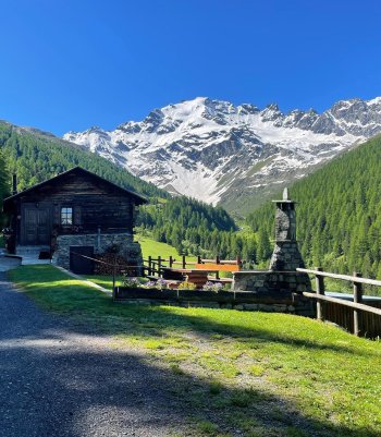
The Val Viola enchants with its fusion of snow-white glaciers, sheets of Alpine water, and the green embrace of its forests.
A long series of peaks over three thousand meters frames the splendid natural scenery. The unspoiled essence of nature amidst the sky-defying mountains and the paths between timeless panoramas invites you to lose yourself in its striking contrasts.

Val Viola - Lake Viola
This is a fascinating and simple trail that crosses the entire Viola Valley, from Arnoga to the Viola Refuge, located at 2,300 m above sea level.
The trail starts in Arnoga, where you can park your car. Here, you take the flat road right on the hairpin bend at the explanatory signs, continuing for about 5 km on an asphalt roadbed to the locality Altumeira. Just so you know, it is possible to reach the Altumeira parking lot directly by car upon payment of the appropriate ticket or with the shuttle service operating in July and August. You then begin to walk the trail correctly, which is almost flat or has short stretches of slight ascent leading directly to Lago Viola. The panorama that opens up before your eyes is immediately spectacular, with views of the imposing peaks that dominate the valley. After about 25 minutes, you come to a fork in the road, where it is necessary to keep to the right (however, the direction is well marked by the appropriate signs). Continuing on the path on a false plain with a constant slope, you will first reach the beautiful little alpine lake and, soon after, the Viola Refuge, at an altitude of about 2,300 meters. From here, it is also possible to quickly reach the Viola Pass, which marks the border with Switzerland.
- Length: 8 km 500 m
- Time: 2 h 40 min (1h 30 min bike)
- Height difference: 439 m
Overview of Val Viola
Opposite the Hotel Viola, in Arnoga in Valdidentro, take path N148, and after two turns uphill, you reach Baite Cagnol, a typical rural settlement.
The path continues uphill through a forest and pastures, offering excellent views of the surrounding mountains: San Colombano, Cima Piazzi, Corno Sinigaglia, Corno Dosde' and Cima Viola.
At the crossroads in the village of Soleir, ascend an unmarked sheep track that leads close to the houses of Sattarona, where you can enjoy breathtaking views over the valley and towards the Val Verva. From here, continue along path N128 via Stagimei and descend through pastures and meadows.
Return on path N290, the main bridleway for Val Viola and Arnoga, the home of the Dog Sledding Centre. There are guided snowshoe tours on this route in winter.
- Length: 10 Km 73 m
- Time: 3 h - 4 h
- Height difference: 567 m


Val Dosdè
Route from Arnoga to the Federico Dosdè Refuge.
Starting from Arngoga, please go ahead and move along path No. 290, the paved road that leads to the Altumeira parking lot (P4). In summer, depending on available places, it is possible to reach this parking lot with your car by purchasing a ticket at the Totem located at the valley access. At the end of the parking lot, the asphalt section ends, and a dirt mule track begins, which, after a short initial section in the forest, opens up with panoramic views of the valley. Continue until you reach a fork in the road, at which you must take the road down the valley (trail No. 292), which leads downhill to the Val Dosdè plain and on to the alp of the same name (Alpe Dosdè). From here, we continue on trail No. 208, which crosses the stream and leads to Rifugio Federico in Dosdè, the end point of our hike.
- Length: 7 Km 300 m
- Time: 2 h 35 m - 1 h 10 m bike
- Height difference: 311 m
Dosdè East Glaciological Trail
The glaciological trail (from Rif. Federico Valgoi in Dosdè to its end) is an unmanned hiking route (E) with short sections for experienced hikers (EE) in a high mountain environment to be hiked with good physical condition, awareness of the dangers and equipment appropriate for a high mountain route. The glacier is an exceptional terrain that must be approached with specific equipment and understanding of one's abilities and the many objective dangers: live ice, crevasses, glacial mills, boulder movements, and debris on the surface.
Leaving the car at the Altumeira parking lot, follow the silvopastoral road to the Altumeira huts, taking trail No. 148 on the left to Alpe Dosdè 1 and the Federico Valgoi refuge. Reaching the refuge, the trail continues parallel to the stream until a fork where you must keep left following the red and white markings. Past the waterfall, you reach a plateau at an elevation of 2350 m, where you can observe the traces left by the Dosdè East glacier during the millennia up to the Little Ice Age 2. From this point on, the white and red markings are replaced by plaques and stone cairns, making the trail less visible. Past a steep section, you reach the plaque relating to the position of the glacier front in 1932 3. One crosses the stream and reaches a plateau at an elevation of 2500 m, where the glacier was located until the 1980s and where one finds, on a gneiss boulder, the measurement mark placed by I. Bellotti in 1953(4) about 20 m from the glacier front. 4. From here, go up the slope to the right to the plaque, marking the position of the glacial front in 1985 5. The trail continues to an altitude of 2600 m where the last panel is located and the Dosdè East glacier can be seen 6. Go down to the valley following the same route as on the way up.
- Length: 12,5 km (A+R)
- Time: 4 h 30 min
- Height difference: 600 m


Val Verva
Val Verva was the doorway to the Count of Bormio from the Bassa Valtellina.
Still today, the quiet, flowing dirt road its length allows bikers to link the routes from the Alta Valtellina directly to the Val Grosina, avoiding Switzerland. From Eita, it is possible to head downhill to the village of Grosio without touching the asphalt, riding on the new route Lagrosina.
During the ascent, we are accompanied by two long ridges: one going from the Monte Verva to the Pizzo di Dosde' on the right and the other from the Corno delle Pecore to the Corno Sinigaglia on the left.
But the real protagonist remains the Sasso Maurigno, who dominates the passage with its unmistakeable shape and which we begin to make out while entering the valley.
- Length: 31 km 207 m
- Time: 4 - 6 h a piedi
- Height difference: 1.235 m
Val di Campo
From Arnoga in Valdidentro, you reach by car or shuttle bus (see municipal regulations) the Altumeira parking lot. Continue on foot along the terminal part of Val Viola to the refuge of the same name. From here, continue on the sent. N290 to the border saddle at an altitude of 2470 m. Entering Switzerland, follow the signs that lead you to overlook the valley characterized by lakes and conifers. With a wide turn to the north, you pass the Pian de la Genzana to divulge at the Campascio terrace. The path, now steeper, continues near Val Viola Lake, which has a tiny wooded islet. Keeping to the hydrographic right, it continues touching the Lach da Scispadus and leaving the Lach da Saoseo a little to the left. One last descent, and you are at Longacqua, where the Saoseo Refuge stands. From here, a dirt road closed to traffic crosses Val di Campo and descends to Sfazu on the Bernina road.
- Length: 10 Km 542 m
- Time: 3 h 10 min
- Height difference: 410 m

 Info & commuications