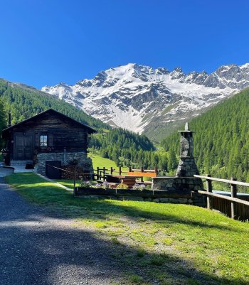
The Val Viola enchants with its fusion of snow-white glaciers, sheets of Alpine water, and the green embrace of its forests.
A long series of peaks over three thousand meters frames the splendid natural scenery. The unspoiled essence of nature amidst the sky-defying mountains and the paths between timeless panoramas invites you to lose yourself in its striking contrasts.

Overview of Val Viola
Opposite the Hotel Viola, in Arnoga in Valdidentro, take path N148, and after two turns uphill, you reach Baite Cagnol, a typical rural settlement.
The path continues uphill through a forest and pastures, offering excellent views of the surrounding mountains: San Colombano, Cima Piazzi, Corno Sinigaglia, Corno Dosde' and Cima Viola.
At the crossroads in the village of Soleir, ascend an unmarked sheep track that leads close to the houses of Sattarona, where you can enjoy breathtaking views over the valley and towards the Val Verva. From here, continue along path N128 via Stagimei and descend through pastures and meadows.
Return on path N290, the main bridleway for Val Viola and Arnoga, the home of the Dog Sledding Centre. There are guided snowshoe tours on this route in winter.
- Length: 10 Km 73 m
- Time: 3 h - 4 h
- Height difference: 567 m
Dosdè East Glaciological Trail
The glaciological trail (from Rif. Federico Valgoi in Dosdè to its end) is an unmanned hiking route (E) with short sections for experienced hikers (EE) in a high mountain environment to be hiked with good physical condition, awareness of the dangers and equipment appropriate for a high mountain route. The glacier is an exceptional terrain that must be approached with specific equipment and understanding of one's abilities and the many objective dangers: live ice, crevasses, glacial mills, boulder movements, and debris on the surface.
Leaving the car at the Altumeira parking lot, follow the silvopastoral road to the Altumeira huts, taking trail No. 148 on the left to Alpe Dosdè 1 and the Federico Valgoi refuge. Reaching the refuge, the trail continues parallel to the stream until a fork where you must keep left following the red and white markings. Past the waterfall, you reach a plateau at an elevation of 2350 m, where you can observe the traces left by the Dosdè East glacier during the millennia up to the Little Ice Age 2. From this point on, the white and red markings are replaced by plaques and stone cairns, making the trail less visible. Past a steep section, you reach the plaque relating to the position of the glacier front in 1932 3. One crosses the stream and reaches a plateau at an elevation of 2500 m, where the glacier was located until the 1980s and where one finds, on a gneiss boulder, the measurement mark placed by I. Bellotti in 1953(4) about 20 m from the glacier front. 4. From here, go up the slope to the right to the plaque, marking the position of the glacial front in 1985 5. The trail continues to an altitude of 2600 m where the last panel is located and the Dosdè East glacier can be seen 6. Go down to the valley following the same route as on the way up.
- Length: 12,5 km (A+R)
- Time: 4 h 30 min
- Height difference: 600 m

 Info & commuications