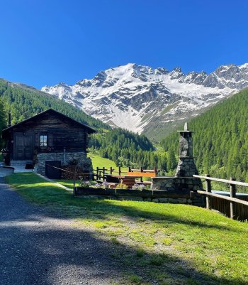
One of Valdidentro's most unusual and lesser-known valleys, the magnificent Val Vezzola, offers views and panoramas that excite every time.

Val Mora (1) (1)
The conformity and dark composition of its bed gave its name to this small alpine lake, where peace and silence reign supreme. Leaving its shores and descending along the path, you reach Alpe Trela or turn right onto path 1301 in Valle Vezzola.
From Passo di Foscagno, take trail N130 northwards, which gradually rises to the western flank of Monte Rocca. Passing the junction with the service road from the valley, continue zigzagging up to the saddle at an altitude of 2645. Here, we continue south-eastwards, shortly reaching the rather deep Lago Nero below, one of the many bodies of water unknown to most hikers. From here, there is the possibility of continuing to Malga Trela, the lakes of Cancano, or Sant'Antonio di Scianno. It is possible to encounter some shy chamois grazing along the track, which is a little frequent.
- Length: 3 Km 790 m
- Time: 1 h 40 min
- Height difference: 369 m
Val Trela
Agriculture in Alta Valtellina Due to its pasture wealth, Alta Valtellina has always been a land dedicated to cattle breeding. The village dairies that process the milk produced by small farms to make typical cheeses are still preserved in this tradition.
From Sant'Antonio di Scianno, follow path N196 to Alpe Gattonino. Here, turn right onto a sheep track that climbs the meadowy slope and penetrates the Cadangola Valley until reaching Alpe Vezzola, at the beginning of the plateau of the same name. It is a characteristic plateau with a few partly restored huts surrounded by summits such as Monte Trela and Dosso Rosaccio. We continue across the valley until we come to a fork in the road: we ascend to the right along path N130 until we reach the pastures at Alpe Trela. Now, on a farm track, you cross the stream and look out over the Val Corta, a rocky gorge where you can admire the geological layers along the slopes of Cima Doscopa. Cross the Val Pettini and continue along the broad road alongside the Cancano dams and Lago delle Scale until you reach the Torri di Fraele. From here, you descend along the hairpin bends of the Cancano road and return to Sant'Antonio.
- Length: 23 Km 800 m
- Time: 7 h 15 min
- Height difference: 695 m


Val Vezzola - Foscagno
It is a particularly impressive walk with panoramic views of Valdidentro. The larches' golden colors are especially appreciable in autumn.
From Sant'Antonio di Scianno, follow trail N196 to Alpe Gattonino. Here, take a right onto a cattle track that climbs the meadowy slope and penetrates the Cadangola Valley until you reach Alpe Vezzola, at the beginning of the plateau of the same name. This is a characteristic plateau with some partly restored huts and surrounded by summits such as Mount Trela and Dosso Rosaccio. From here, you follow the mule track on the left, toward the water intake, and after about 15 minutes, continue on path N 196.1, which enters the woods (there is a sign indicating Foscagno). After a little more than 2 km, the trail leaves the charming forest, and a striking viewpoint appears in front of it; a little further on, take the mule track that climbs until you reach the first Foscagno pond at an elevation of 2,250 m. Crossing the state road, you find the main lake and the other smaller lakes nearby.
- Length: 14 Km 200 m (A+R)
- Time: 5 h - 15 min
- Height difference: 789 m
 Info & commuications