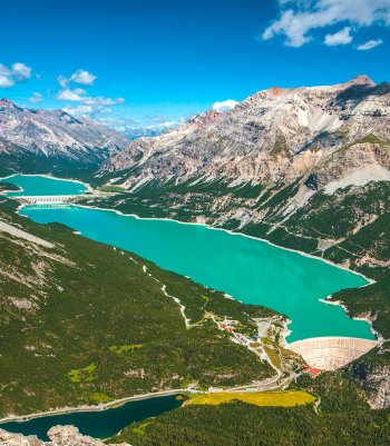
One of the best-known valleys in the entire Alta Valtellina, Cancano, with its homonymous lakes, enchants visitors with its natural and historical heritage.
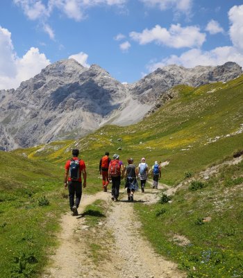
An ideal starting point for numerous hikes or mountain bike tours, the Cancano and Fraele valleys offer countless experiences in picturesque settings in the heart of the Stelvio National Park.

Cancano Lakes Tour
The route, immersed in the splendor of the Stelvio National Park, is ideal for a day on foot or by mountain bike with the whole family. It is not difficult and is characterized by refreshment stops and picnic areas.
The start is near the Ristoro Monte Scale along the N199 dirt road. On a route with little difference in altitude, you ride along the Cancano and San Giacomo di Fraele dams. The route includes the complete circumnavigation of the San Giacomo dam, crossing the dam, and returning to the starting point.
During the summer season, the area is subject to a regulation that provides for the closure of traffic from 9 a.m. to 6 p.m. and the activation of a shuttle service: info and updates here.
- Length: 19 Km 279 m
- Time: 4,45 h (bike: 2 h)
- Height difference: 200 m
Ring of Monte Scale
From the Fraele Towers, we ascend the military mule track N197 through a dense wood of mountain pines until we reach a shoulder at the foot of a rock face. Then, we continue along the path between rocks, gullies, and scree.
A final hairpin bend leads to the square overlooked by the Monte Scale Barracks. From inside the Barracks, a tunnel with two hut-shaped powder magazines allows you to cross the saddle and emerge on the mountain's opposite side. A relatively narrow path leads to the Cross of Monte Scale, which offers an excellent panoramic view of the entire Bormio area.
The return is planned along the northern flank of Monte Scale along the sent. N197. The trail initially crosses meagre pastures and then penetrates into a dense wood of mugo trees until reaching Lake Scale. Skirting the lake, we return to the starting point.
- Length: 7 Km 767 m
- Time: 3 h
- Height difference: 500 m


Val Forcola
From the car park near the Sant'Erasmo church, follow the N184 mule track to the car park immediately after Alpe Solena, where you take the sent. N145 on the left, entering the Val Forcola canyon.
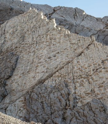
After the Malga Fornelle hut, at the fork, continue straight along the Forcola Valley in an unusual environment in the Retiche due to the abundance of carbonate rocks dominated by the mass of Monte Sumbraida. One passes the Malga Forcola and comes to a fork in the road. It is possible to reach the Bocchetta di Forcola, where the first Italian line was located during the Great War, turning right along the path N146 instead of reaching Bocchetta di Pedenolo. The path continues downhill along numerous hairpin bends to the Piano di Pedenolo and the alp of the same name.
Here, there is a comprehensive view of the pyramid of Monte Sumbraida. The mule track continues downhill along the rock face with numerous hairpin bends and well-constructed traverses until it returns to the junction with the Valle della Forcola. The N145 carriage road leads back to the starting point.
- Length: 17 km 832 m
- Time: 6 h (bike: 4h)
- Height difference: 900 m
Val Pettini and Val Trela
From the parking lot located after Alpe Solena, we take the sent. N145 and enter the canyon of the Forcola Valley. After Malga Fornelle, at the fork, continue straight along the Forcola Valley in an unusual environment due to the abundance of carbonate rocks, dominated by the mass of Mount Sumbraida. You pass the Malga Forcola and come to a fork in the road.
Going straight on, it is possible to reach Bocchetta di Forcola, where the first Italian line was located during the Great War, turning right along sent. N146.1 instead you reach Bocchetta di Pedenolo. The trail continues downhill along numerous hairpin bends to Piano di Pedenolo and the hut of the same name.
Here is a comprehensive view of the pyramid of Mt. Sumbraida. The mule track continues downhill along the rock face with numerous switchbacks and well-constructed traverses until it returns to the junction with the Forcola Valley. Via the N145 carriage road, you return to the starting point.
- Length: 13 km 814 m
- Time: 5 h (bike: 3,5 h)
- Height difference: 700 m


Val Mora (1)
- Length: 5 Km 364 m
- Time: 1,45 h (bike:1 h)
- Height difference: 330 m
Valle del Gallo
The short hike starts from the parking lot near the Church of St. James of Fraele and follows the sent. N199. In a few steps, you reach Fraele Pass. The trail descends for 1 km, leading to a junction. It continues to the left, crossing Val Bruna on a bridge and dividing at Grasso di Pra' Grata.
This hike leads you to one of the most intriguing spots in the area. The vast valley floors, covered in limestone pebbles that mirror the Apennine scenery, are a unique geological feature. The wild and almost forgotten cliffs of the Piz Murtarol coastline and the node of the Cassa del Ferro add to the area's distinctiveness, sparking curiosity about their origins.
Along the path N182, you will soon be at the Gallo Bridge, and from here, you can continue to the Gallo Pass. It is not uncommon to see grazing ungulates in this area, part of the Stelvio National Park.
- Length: 3 km 846 m
- Time: 1 h (bike: 20')
- Height difference: 100 m


Val Mora
Follow the path from the parking lot near the Church of St. James of Fraele, N199, and you are at Fraele Pass in a few steps. The trail descends for 1 km, reaching a junction. It continues to the right toward the outlet of Val Mora. Going over the northernmost alluvial deposits of Val Paolaccia, you pass the cone of Val della Casina and reach Val Mora Pass. Having reached Swiss territory, continue into the wild gorge on the hydrographic left of the stream until the last bottleneck in front of the shelves of Il Grass. Across a bridge, you reach the right bank of the river, and after a few hundred meters, you pass Paluetta and cross the stream that descends from Doss dal Terminal. A little further on, almost opposite the Val Murtarol, you come out into the Alp Mora plateaus.
This route is part of the Strada d'Alemagna, also called the Wine and Salt Route.
- Length: 7 Km 457 m
- Time: 2 h 10 min (bike: 50')
- Height difference: 150 m
 Press releases
 Info & commuications
 Info & commuications
 Info & commuications
 Info & commuications
 Info & commuications